The Dubai Metro, managed by the Roads & Transport Authority (RTA), is a modern and efficient public transportation network. The Dubai Metro serves as the backbone of the transportation for the city. Over 5 million passengers travel through the metro in a month. It has become an integral part of daily life in Dubai. You must have enough information about the Dubai Metro map and its routes to move around Dubai and explore the city with ease.
Dubai Metro covers all the major areas of the city with its two operational lines, called the Red Line and the Green Line. Also, Blue Line is in progress, which is expected to be operational in 2029 as per RTA Dubai. In addition, the Dubai Metro Map also has a new working line named Tram Line.
Here you can find all the information about the transport system in Dubai, like the Dubai Metro, which includes the Metro Map, zones, routes, stations, and timings of the Dubai Metro during weekdays and holidays. You can also find Dubai Metro ticket prices and NOL card information for travel in the Dubai Metro.
Dubai Metro Transport System
Dubai’s transport system is one of the modern systems for travel around the city. Dubai Metro is a modern, fully automated rail system in Dubai, United Arab Emirates. This transit system is provided by the Roads & Transport Authority (RTA) in the UAE. It’s known for its efficiency, cleanliness, and convenience, offering residents and tourists an excellent way to navigate the city. If you are living or on a tourist visa in Dubai, you must be familiar with the Dubai Metro Map and routes to move around the city.
The Future of Urban Transit
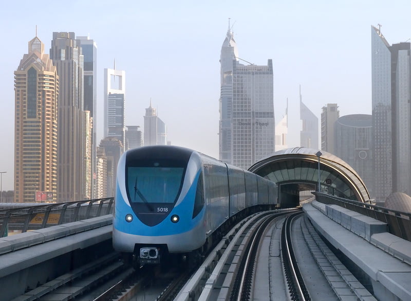
The Dubai Metro is a modern and driverless train system. The government’s major aim in starting the Dubai Metro was to reduce traffic in the city. The Metro project in Dubai was the 1st step towards accomplishing this goal. Moreover, it allows residents to use the Dubai Metro instead of using their cars to reduce road traffic. This driverless Dubai Metro plan started successfully, and more than 5 million people travel by metro trains every month. It continues to spearhead public transport in Dubai.
Dubai’s Geographic and Urban Transit
Dubai Metro Map shows a schematic of the Metro that plays an important role in the city. Dubai is a territory of the UAE. It has a population of roughly 3 million people. Geographically, it is situated halfway between Asia and Europe. Moreover, Dubai is landlocked from 3 sides by the Arabian Desert. It covers an area of about 4,114 km2. In the past few decades, Dubai’s economy has skyrocketed.
Efficient and Rapid Transit System
Dubai is now the tourism capital of the UAE. Dubai holds the world’s best architectural structures, such as Burj Al Arab and Burj Khalifa. These masterpieces attract millions of people from around the world for tourism. The enormous number of tourists also brings a heavy burden on Dubai’s local transport infrastructure. Due to this heavy burden, Dubai needed an express transport system that could travel from one end of the city to the other.
Construction and Cost for Dubai Metro
The metro plan in Dubai was the answer to this problem. The Road and Transportation Authority (RTA) Dubai took responsibility and started construction in 2006. It lasted about three years, and in 2009, the Dubai Metro was ready to serve. It had only nine stations working out of 28 Red Line stations. The cost of this project was about 4.2 billion USD, according to the Road and Transportation Authority (RTA) of Dubai.
A Symbol of Luxury and Modern Lifestyle
This system has eased many of the people in Dubai for daily travel. As the city is known for its extravagant lifestyle, the Metro was a pure impression of their luxurious way of life. The Road and Transportation Authority (RTA) produced one of the most modern, comfortable, and reliable Metro systems that the world has ever seen. The trains are air-conditioned and have a separate section for women/children and men. This Metro not only connected Dubai from end to end but also linked it to the neighboring emirates as well.
Dubai Metro: Master Piece of Architecture, Automation, and Innovation
The architecture of the Metro was designed by an international architectural company, Aedas. This firm was formed in 2002 with the alliance of three different companies from all over the world. Automatic Train Operation is used to automate all of the trains in Dubai Metro; this makes all the trains driverless. The trains are fully air-conditioned as well as the stations.
The Dubai metro station map also has platform edge doors, and trains have a window panel that offers a great view of the city during the ride. Dubai Metro held the record of the world’s longest driverless metro, with a total route length of about 75 kilometers, up until 2016. However, Red Line is still the world’s longest single-line driverless metro with a route length of about 52.1 km.
Latest Dubai Metro Map 2025:
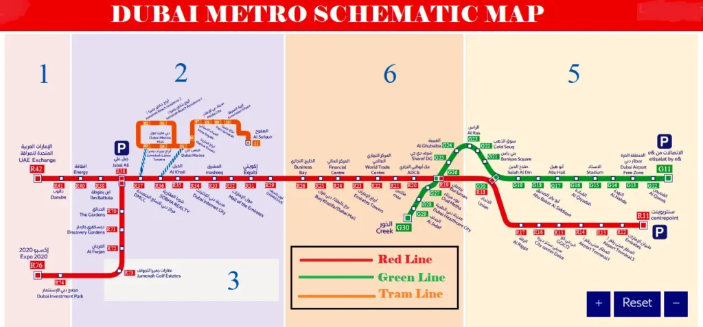
Types of Dubai Metro Map
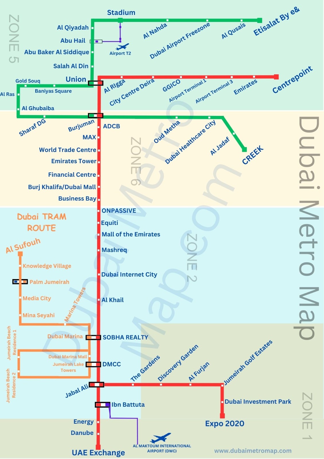
There are two main types of Dubai Metro Map available at present. You can check these maps to get to know the zones and areas covered by the Dubai Metro. Here I provide both types of Dubai Metro Map with brief descriptions of each of them.
- Dubai Metro Schematic Map
- Dubai Metro Interactive Map
Let me show you the Schematic and Interactive Dubai Metro Map with different zones and stations/places of Dubai.
1. Dubai Metro Schematic Map
This simplified Dubai Metro Map shows only the stations on the path of all three Lines. This map also mentions the transport zones, which are useful for users when calculating the fare.
2. Dubai Metro Interactive Map
The Dubai Metro Interactive Map is a bit different from the schematic map. Because the interactive map is a live map. You can click on any metro symbol on the Red Line to know the name of the station and the Dubai Metro Timing.
Dubai Metro Route Map
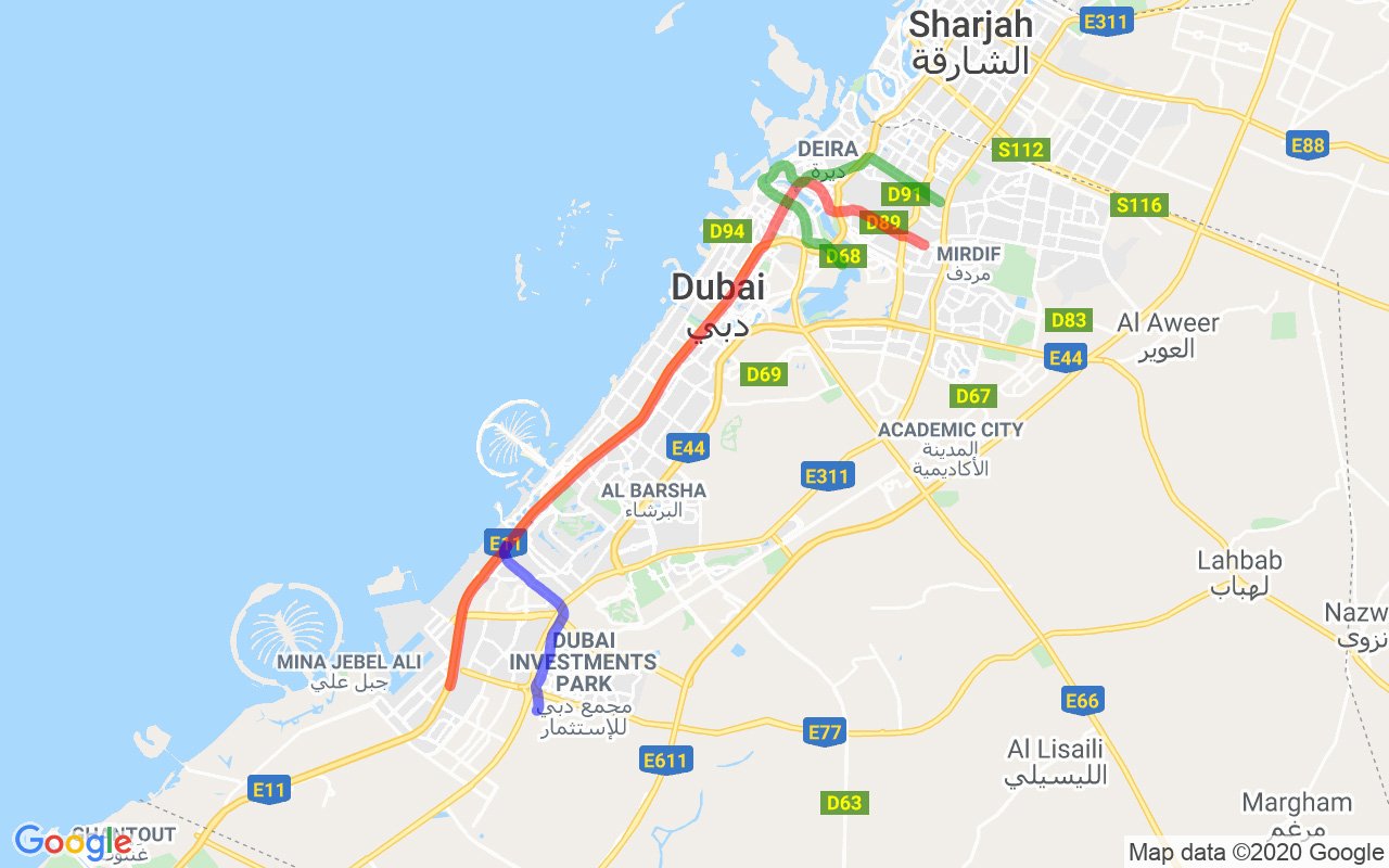
As shown above, in the Dubai Metro Route Map, the Metro Lines are drawn on the Dubai City Map. These Red and Green lines indicate that the Dubai Metro Trains run across the entire city to provide a fast and traffic-free traveling service.
Dubai Metro Route
The Dubai Metro green line is supposed to connect Jebel Ali to Expo 2020. The construction started in 2017, and the proposed completion date was the end of 2018. However, it is not active, but according to the Road and Transportation Authority (RTA), it will be operational by May 2020. The total length of this line is about 14.5 km, with seven working stations. The estimated cost of this project is about 2.45 billion US Dollars, and the cost per kilometer is calculated to be approximately 186 million US Dollars per kilometer. The trip time and the average speed are unknown as the line is not operational yet.
Dubai Metro Frequency
Is the Dubai Metro operating for 24 hours? Dubai Metro trains are available on weekdays as per the given timetable. The Dubai Metro frequency is different between peak operating hours and off-peak hours. Trains run frequently on both lines to fulfill the traveling needs of the passengers. The train timings during normal and peak hours are given below.
During Peak Hours – After every 3 Minutes and 45 seconds (3.45 Minutes)
During Off-Peak Hours – Every 7 Minutes
This is very important, and you must remember that the first and last train times vary for each station.
The metro operating hours can also change during public holidays. Moreover, the Metro Trains’ availability information is available on the screens of all the Metro stations. You can check the latest arrival and departure train timings on these display screens.
Dubai Metro Baggage Policy
There is a baggage policy for traveling through the Dubai Metro. The RTA authorities allow limited bags for passengers, so you must know the baggage policy and strictly follow it.
Two Suitcases are allowed per person/passenger.
One Large Suitcase – Maximum Dimensions Allowed: 81 cm X 58 cm X 30 cm
One Small Suitcase – Maximum Dimensions Allowed: 55 cm X 38 cm X 20 cm
Ensure you carry only two suitcases/bags per person when using the Dubai Metro. Moreover, you must keep your suitcases in the baggage area provided in your cabin.
Dubai Metro Red Line
Dubai Metro Red Line starts from the Centrepoint and goes up to the UAE Exchange. This line also has an extension to the Expo 2020 site. The total length of this line is about 52.1 kilometers, and 5 kilometers of those are underground lines. The construction of the Red Line started in 2005 and was completed by the end of 2009. The cost of this project (including the Green Line) is around 7.6 billion US Dollars, and it has 35 stations. This means the average cost per kilometer of this line is almost 102.2 million US dollars. The top speed on this Line is about 95 kmph (59 mph), and the total trip time is estimated to be 70 minutes.
Dubai Metro Green Line
Dubai Metro Green Line connects Etisalat By e& with Creek, and it has a total of 20 working stations. The total length of this line is measured to be 22.5 kilometers, with 7.9 kilometers underground. There are eight underground Metro stations. The construction of this line started in 2006, but due to some global crisis, it didn’t finish on the proposed completion date.
Due to delays, the proposed completion date was March 2010, but this line was officially opened in September 2011. As mentioned above, this line was constructed alongside the Red Line, and the total cost was about 7.6 billion US Dollars or 28 billion AED. The cost/km was roughly 102.2 million/km. It has a trip time of 40 minutes, with a max speed of 110 kilometers per hour (68 mph), and stops 20–30 seconds at each station.
Dubai Metro Blue Line
The metro consists of two main lines, the Red Line and the Green Line, which connect various parts of Dubai, covering major attractions, shopping malls, and residential areas. The Dubai Metro Blue line is the new addition to the existing Red and Green lines. The Dubai Metro Blue Line project is on its way, and RTA has a plan to kick off the service in 2029 using the Blue Line.
The Completion of Dubai Metro’s Red and Green Lines
The next phase of the Metro Plan Dubai was to build up the remaining 18 Red Line Stations along with the new Green Line. The Green Line connected Etisalat to Creek with 18 operating stations. The construction began in February 2010, and it finally came to an end in 2011. This whole project cost the Road and Transportation Authority (RTA) an extra 2-3 Billion Dollars. The Metro was again opened in March 2011 with ten new trains. At that time, the Dubai Metro had 22 working trains to serve the Red Line and Green Line.